Sunday, January 15, 2012

Hollenbeck Canyon


So far I've done the longer loop twice: once in the morning and once around noon, both in the month of January. Noon was a real bear with the sun beating down on us the whole time. The morning hike was perfect in comparison. The cool temps in the early hours were a little rough until we got going. But once the fog banks hugging the lower regions burned off a little as the sun came up, we were good to go. This is a great network of trails if you're looking for something not too strenuous, but with some decent distance.

The trails winding through Hollenbeck Canyon Wildlife Area and the neighboring grasslands offer the option of several different routes that will take you on either a few miles of hiking, to six or more. Some hug the base of a small range of mountains, others take you down paths shaded by canopies of trees, and others lead up, down and around rocky rises.

Once the site of a working ranch, there are still remains of the corrals and even the foundation of a brick building:


You'll thank me for this tidbit: bring binoculars! Between the natural features of the land and the wildlife -- more specifically the hawks coasting on the winds and perching on craggy peaks -- there are plenty of sights you'll want to get a closer look at.

Winter streambeds are dry washes or they barely trickle along, which in some places can be a blessing as there are a few points where you'll be picking your way across them one stone at a time or detouring around altogether. The multi-use trails are shared by mountain bikers, horses, dogs and, during certain times of the year (and to the dismay of my hopelessly bleeding heart), hunters.

Thursday, September 22, 2011

Torrey Pines: State Reserve and Beach

This post pays tribute to Jerry Schad and the inspiration he continues to instill in Southern Californians to rediscover the great outdoors. Thanks Jerry, happy trails to you.
Jerry Schad
November 3, 1949 to September 22, 2011


The cover of my dog-eared copy of Afoot and Afield in San Diego County motivated me more than once to pay a visit to Torrey Pines State Reserve and Torrey Pines State Beach this summer. Here is a collection of visual highlights from recent visits combined with (and as a compliment to) excerpts from Jerry's "bible of San Diego hiking."


"The rare and beautiful Torrey pines atop the coastal bluffs south of Del Mar are as much a symbol of the Golden State as are the famed Monterey cypress trees native to central California's coast. Torrey pines grow naturally in only two places on earth: in and around Torrey Pines State Reserve and on Santa Rosa Island, off Santa Barbara."


"The popular beach trail originates at the parking lot at the museum and intersects with trails to Yucca Point and Razor Point. Fenced viewpoints along both of these trails offer views straight down to the sandy beach and surf."


From the Reserve you can make your way down to the beach and a few areas of tidepools along the vast stretches of sand. Prepare to enjoy a wide variety of wildlife if you have a keen enough eye. It's not uncommon to see juvenile leopard sharks in the shallows, osprey gliding overhead, tidepools teeming with marine creatures, and shorebirds strolling the sands.


"These are the tallest cliffs in western San Diego county. A close look at the faces reveals a slice of geologic history: the greenish siltstone on the bottom, called the Del Mar formation, is older than the buff or rust-colored Torrey Sandstone above it. Higher still is a thin cap of reddish sandstone, not easily seen from the beach - the Linda Vista Formation."


"There are only a few places along the Southern California coastline where you can hike for miles in a single direction and not catch sight of a highway, railroad tracks, powerlines, houses, or other signs of civilization. The Torrey Pines beaches are one such place. Here, for a space of about three miles, sharp cliffs front the shoreline and cut off the sights and sounds of the world beyond."


Donations in Jerry’s memory may be sent to: Friends of Balboa Park, 2125 Park Boulevard, San Diego, CA 92101. Funds will be used to benefit the Balboa Park Trail System in trail maintenance, improvements, maps and other forms of information dissemination.

Sunday, June 26, 2011

Iron Mountain in pictures


Iron Mountain is a great north San Diego county hike, especially for an overcast day, or crisp early morning. Can't beat the views, and you're sure to meet plenty of nice people along the trail. I'll be enjoying a backseat ride while the pictures do the talking here.


Wednesday, March 30, 2011

Cowles Mountain and Pyles Peak


If you Google images of Cowles Mountain, themes will quickly emerge: stunning panoramic views of San Diego, people with triumphant grins posing in a variety of unique and/or weary positions next to the monument at the top, individuals being rescued from the trail due to injuries or other manner of distress, and yet more stunning panoramic views of San Diego. So it goes without saying that this is one popular mountain, and for good reason.

The worst part about Cowles is also the best part if you're a female who enjoys a good solo hike: it's well-populated on any given day of the week. The safety factor in this regard is a big selling point and I appreciate that about Cowles - pronounced "coals," not like the plural for hooded garments, "cowls," although the popular pronunciation is the latter. The trail that saddles over to Pyles Peak from the top of Cowles is a pleasant chaser to the bustle you experience on the way up. More on this later.

I liken the high traffic of the Golfcrest Drive trailhead that snakes around and finally switchbacks up to the summit as a one-lane, two-way highway designed to teach us the merits of coexisting with our fellow foot travelers -- all of whom are ascending and descending at a wide range of speeds. Whether it's the family of five encouraging their fussy eight-year-old that it's just a little further, the clutch of work friends bemoaning their tyrannical boss, the athletes bounding past with a singular mission, serious hikers making a trial run in full gear regalia, etc., Cowles offers a great workout no matter how fast or slow you choose to go.


On to Pyles Peak! The peace and serenity of the trail is restored after just a few turns, and you can once again hear your boots crunch pleasantly on rock and gravel. On the busiest of days I have passed five or so people en route to my destination, but I usually see only one or two at most. If you're early enough you'll catch a glimpse of California Quail making morning rounds of their favorite clearings, and springtime yields all manner of colorful blooms.

This trail winds up, down and around at a far more forgiving grade and offers stunning views. The final steep stretch to the peak will make you earn the amazing reward at the top, though (watch your footing here for sure). Once to the top, the trail peters out as you meander through tall grasses and rocky outcroppings. There is expansive scenery aplenty at this point, so bring your camera! If there ever was a place to sit a spell, breathe, and clear your head, this would be it.

At the risk of overthinking the notion, I've come to the conclusion that Cowles and Pyles make a dynamic pair in that they manage to compliment one another by way of their dramatic differences. Frenetic energy versus placid, if you will. I get a sense that their impact on the senses would be lessened were they not hand in hand, thus offering a deeper appreciation for what each has to offer. So if you want to get a true feel for one, be sure to get to know the other.

Wednesday, March 23, 2011

Cabrillo National Monument


A friend of mine grew up in Hawaii. To my surprise, she high tailed it to the mainland as soon as she was old enough to escape what she described as the small town confines of the islands. As alien of a concept as this seemed to me, the realization quickly sunk in: being a native of any particular place, even if it’s considered paradise by some, can easily numb you to all that your town has to offer. Which leads me to this post on the Cabrillo National Monument in San Diego, California.

As they say, the best way to reconnect with your home town is to shuttle out-of-town guests around for a week of sightseeing. Well, if you live in San Diego, then be sure to take Aunt Maude to Cabrillo next time she visits from Vermont. Chances are you're long overdue for a trip there anyway, and who doesn't want to smell the fresh, salty air and watch the waves roll in and crash against the cliffs?

Being a native San Diegan, I’m no stranger to Cabrillo National Monument. And like any true SD native, you were probably just a kid when mom and dad first took you up there to see Juan Rodriguez Cabrillo's statue standing proudly before an awesome backdrop of the county. As if a minimal entrance fee that now includes the access road to the tide pools could stop us. The visitor center is always fun to browse through with all the great books and information, but our most recent visit was all about the nature trails.

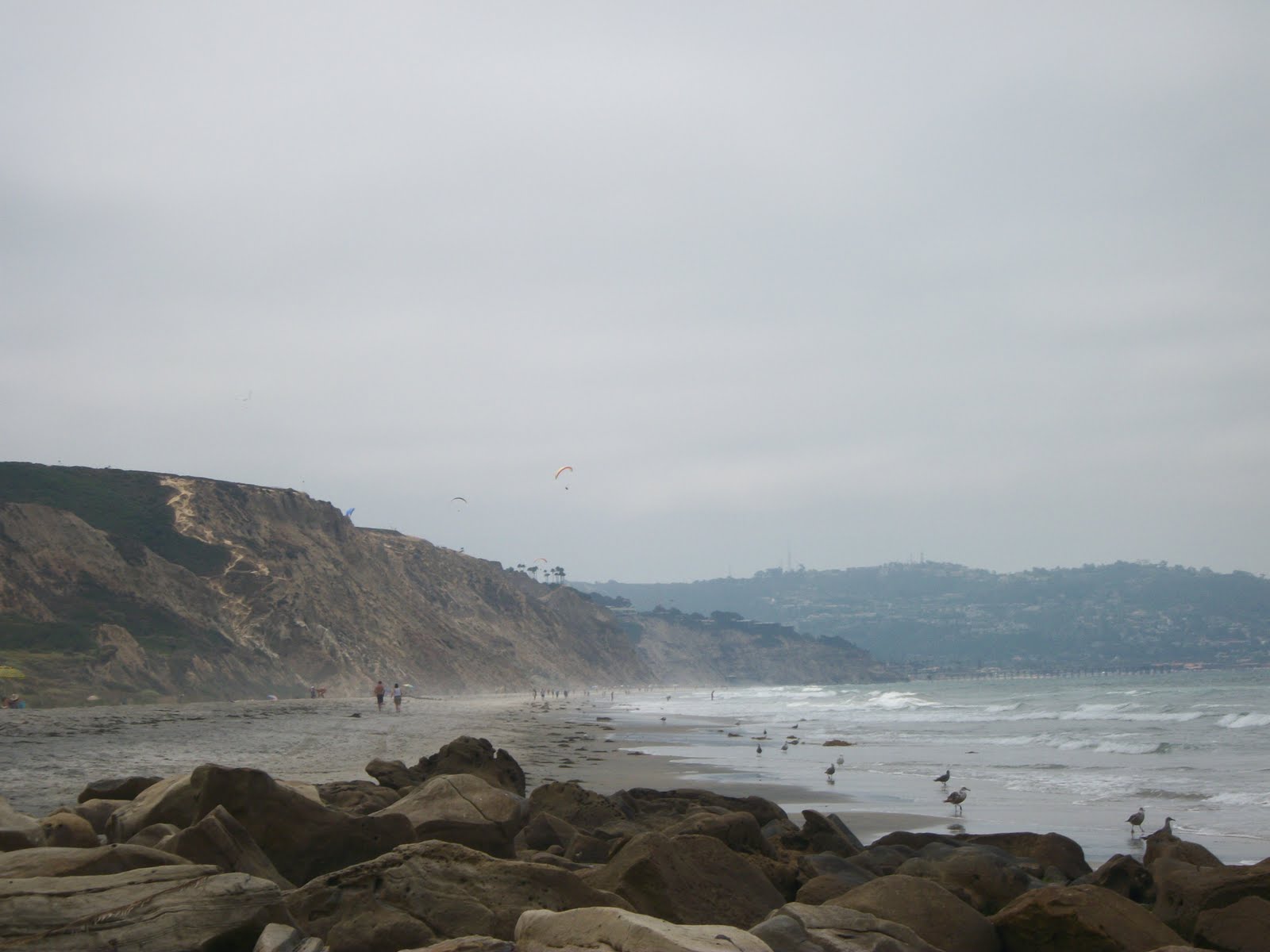
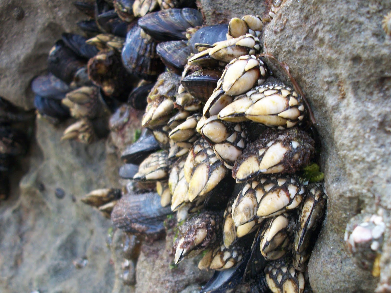
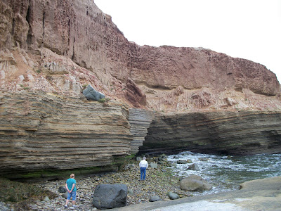
A note about the tide pools if you've never been: familiarize yourself with a San Diego tide chart pronto, and visit during the next minus tide. You'll thank me for this later when you're up close and personal with starfish, sea anenome, marine hermit crabs, and maybe even a lobster or an octopus. Roll the ol' pant legs up, wear your best non-skid sport sandals, and keep your eyes peeled for all sorts of cool stuff. Did I mention to wear your best non-skid sport sandals? The algae-coated rocks will not be your friend if you don't tread carefully while scoping out the sealife. Prevent an embarrassing header into the very pool you're gazing into, and explore with care.


Most people are so wrapped up in the tidepools that they forget about the bayside trail, which starts near the Old Point Loma Lighthouse but is easily overlooked if you're busy admiring the lighthouse's impressive Fresnel lens.

Confession time: when I see the same plants over and over I eventually start to ask myself what the heck they are. Unfortunately, my inquisitive nature is no match for my lack of an effective attention span, and all thoughts of Googling them one by one the minute I get home are quickly lost. Thus continues my pattern of staring endlessly at mysterious, unidentified plantlife.

This, thankfully, is remedied at Cabrillo National Monument by nifty signs placed strategically among the native plants, stating their common and scientific names. The bayside trail is lined with such signs, not to mention the rich aroma of sage hanging in the air. Then there's the constant traffic of boats coming and going from the San Diego bay, and a cool view of North Island, Coronado, and beyond. But I digress.

On this visit, one plant sign in particular yielded a disappointing discovery. After years of admiring the delicate seed pods of a native plant clustered in groups along several San Diego nature trails, I found its undeserving name to be Locoweed. Really? How could such a pretty plant be called a weed? And a loco one at that? I demand a renaming of this plant immediately, and make it something more deserving this time around.


Trekking up and down cliffs all morning works up a healthy appetite. Time for squid sandwiches from Point Loma Seafoods! And if you're not hungry when you pull in, you will be after circling the lot for a half an hour trying to find parking. Be prepared for a crowd and brace your wallet for the cost, but above all enjoy some really killer seafood.

While you're doing that, give some thought to your home town and all it has to offer. Then make a little promise to yourself to rediscover those things that make the city you live in a unique paradise all its own.